
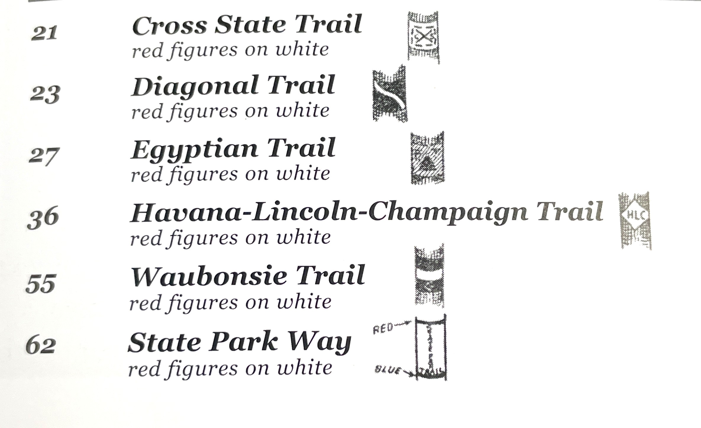
The Egyptian Trail was one of a handful of named auto trails in east-central Illinois created by “good roads” advocates in the middle teens of the early 20th century. It ran the length of Illinois from Chicago to Cairo, deriving its name from the state’s southernmost “Little Egypt” region where the auto trail ended at the confluence of the Ohio and Mississippi rivers.
Before digging into the history of the Egyptian Trail, let’s do a quick survey of auto trails in the area. Each trail was marked, usually on roadside telegraph poles, with its own unique standard and color scheme. South of Champaign County, the Pikes Peak Ocean to Ocean Highway (U. S. Route 36 now) passed through Tuscola on its way from Los Angeles to New York City. The Egyptian Trail crossed paths with its east-west contemporary in Tuscola before heading south out of town on a county road (1000 E now) that is still retains the trail’s name.
East along the Illinois-Indiana border, the Dixie Highway ran along what is now Illinois Route 1 from Chicago to Danville. From there, it turned east into Indiana and eventually made its way through the Deep South to Florida. The Illinois section was marked between 1916-1921 and was among the earliest paved roads downstate.
The Waubonsie Trail was the earliest marked auto trail to run through Champaign County, reported to have been completely marked through the county in 1912 (Champaign Daily News, November 19, 1912). It ran from Danville to Urbana, following what was then known as the Old State Road, continued west through Champaign, then headed southwest through Monticello and on to Decatur. It reportedly took its name “from the old Waubonsie hunting trail which extended through the middle west” (in turn named for an early 19th century Potawatomi leader). It appears, along with the Egyptian Trail (center) and Ocean to Ocean Trail (bottom) on this 1917 state map of “Marked Through Roads.”
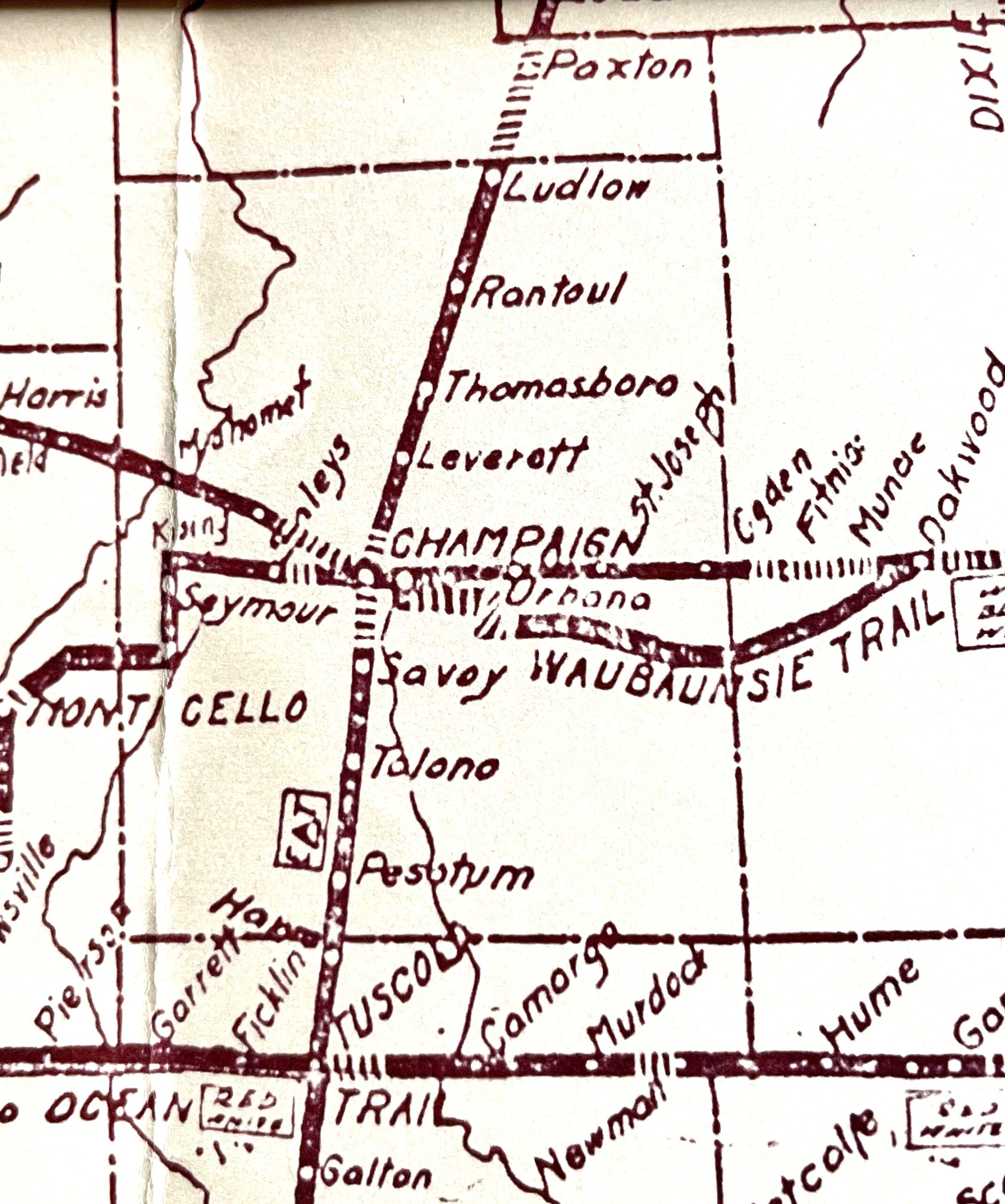
Also running from Danville to Champaign, then on to Bloomington, the Diagonal Trail followed a path that generally corresponds with U. S. 150 today. According to local news reports, it was developed and marked through the county between 1916-1917. In May of 1917, the Daily News reported on a meeting in Lincoln to promote the Havana-Lincoln-Champaign Trail. A Champaign man, H. R. Conkwright, represented the Champaign County Automobile association at the Lincoln meeting and was elected vice-president of the trail organization. It originated at the Egyptian Trail in downtown, left Champaign on Springfield Avenue and continued west to Clinton and Lincoln, following what is now Illinois Route 10.
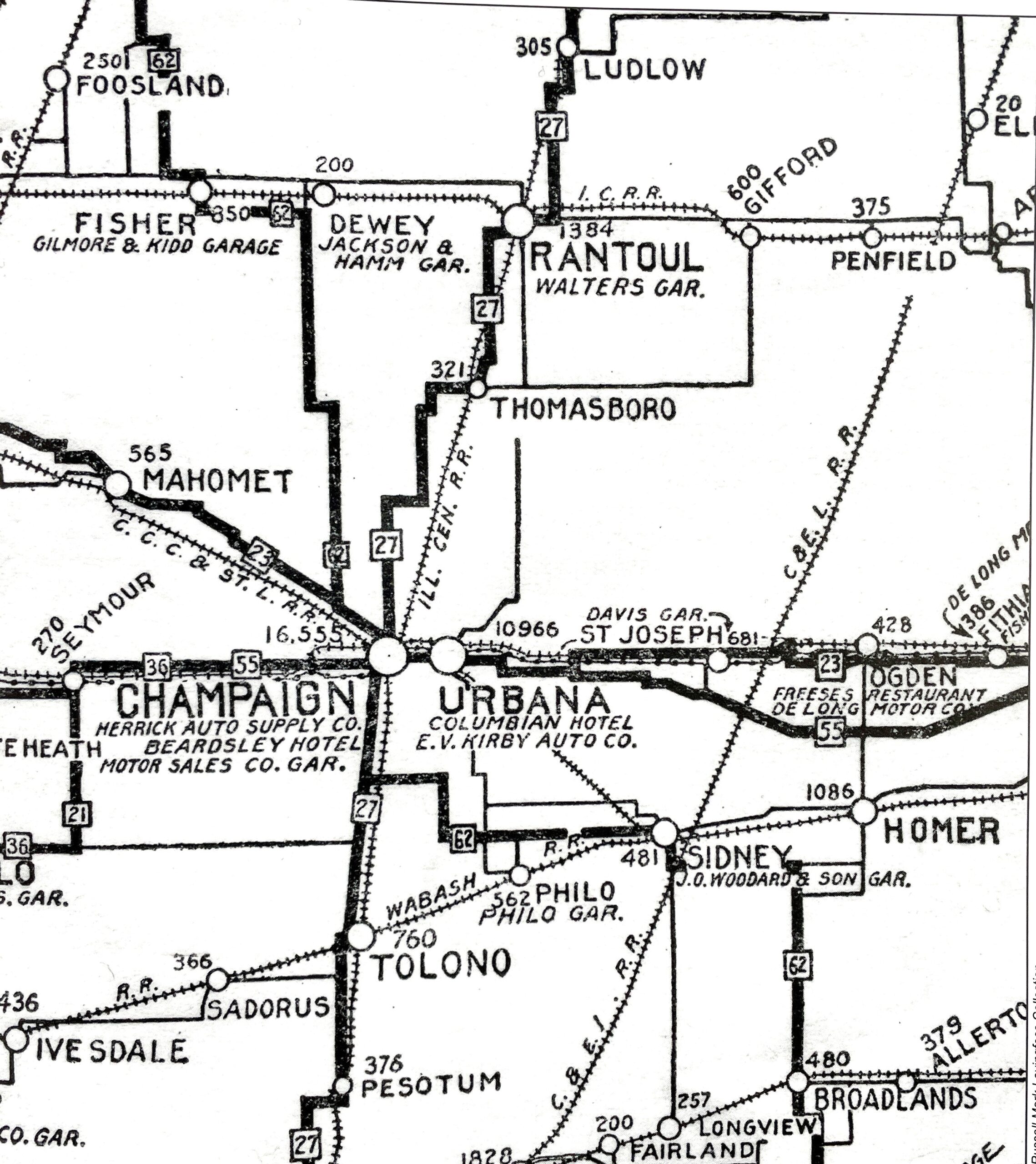
Finally, a section from a 1917 Rand McNally Official Auto Trails Map (left) shows a State Park Way coming south into the county via Fisher and Dewey, joining up with and then following the Diagonal Trail into downtown.
From there it followed the Egyptian Trail south to Savoy before heading east to Philo and Sidney and then south to Broadlands. My search of local newspapers turned up no accounts of this trail.
Regarding this 1917 Rand McNally map, it seemed odd that it also shows numbers corresponding with the named auto trails. The numbering of state highways did not appear until the 1920s, and those assigned then do not correspond with those shown here. Turns out these numbers simply reference a key (shown right) included on the map (also used by official Illinois auto trails maps of this period).
The Egyptian Trail is Born
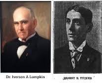
James R. Wright, author of The Egyptian Trail in Illinois, wrote that project was “the brainchild of two Mattoon men, Dr. Iverson A. Lumpkin and Ernest B. Tucker (pictured below), who were keen boosters of their [community] and ardent automobile enthusiasts.” Beginning in early June 1915, a notice announcing the organization of the Egyptian Trail Association “was appearing in newspapers up and down the proposed route,” which was to follow “as closely as possible” the path of the Illinois Central Railroad.
That organizational meeting took place June 15, 1915. The Mattoon Journal Gazette reported that Lumpkin and Tucker were “chosen unanimously to fill the offices of president and secretary-treasurer of the new organization.” Vice-presidents representing the interests of prominent communities along the trail route were to be named. They would be required to donate $5 each and raise additional funds locally to support the project.
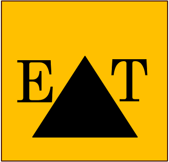
“The Egyptian Trail is to be blazed with pyramids of orange with the letters E.T. in black,” the paper reported. A committee consisting of the two officers and the section vice presidents would determine the locations and manner in which these markers would be placed. Essentially, that empowered them to determine what existing local roads would be selected to be part of the marked route and improved to meet trail standards.
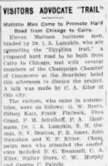
A week before the organizational meeting in Mattoon, the Champaign Daily News (June 8) reported that Dr. Lumpkin, along with 11 other Mattoon businessmen, “met with several members of the Champaign Chamber of Commerce at the Beardsley hotel . . . to discuss the project.” C. A. Kiler, owner of a home furnishings store in downtown Champaign, was among those who spoke at the gathering. Kiler would be named a section vice-president for the project. As such, he pushed for a route through downtown Champaign and, conveniently, right past his Main Street store!
Champaign was originally intended to be “the southern terminal point for the northern division of the [trail] and the northern terminal point for the central division” (Wright). But even though the Urbana Daily Courier (June 9) reported that “Twin City people” had been invited to the organizational meeting in Mattoon, none seem to have attended. Consequently, the Paxton representative in attendance successfully “pushed for his city to have the honors” (Wright).
Blazing the Trail
During the summer of 1915, section vice-presidents worked with county and township road commissioners to determine what existing dirt roads were best suited to be marked and improved as part of the trail. The route was at first blazed with painted markings on telephone poles. Eventually, official 12 x 18 inch signs with a “special yellow” background (“really more of an orange color”), on which a black pyramid with the block letters E and T, also painted in black,” were used to mark the trail (Wright, quoting from the Paxton Record, August 26, 1915).
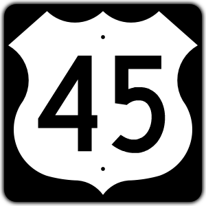
Local newspapers followed the progress of the project in Champaign County with great interest. The Champaign Daily News (July 7) reported, “James Clark of Rantoul was in Urbana this morning on his way to Mattoon, where he intended to make an effort to have the Egyptian trail pass through Urbana.” At the time, the most common route used by auto travelers going north from the twin cities ran from Urbana to Rantoul (U. S. Route 45 today). Although Clark reportedly “endeavored to round up some patriotic Urbana citizens to accompany him on his mission,” the route through Champaign continued to be favored.
Later in July, the Urbana Daily Courier (July 29) reported, “C. E. Kelso and son, Dr. C. E. Kelso, Jr., and George Fiedler were in Urbana Friday laying out the route for the Egyptian trail.” Why they were meeting in Urbana is unclear. Kelso and Fiedler were business owners in Thomasboro (Kelso was also postmaster). The article continued, “The route will come past the Kelso and Fiedler stores, thence, west a mile, thence south and directly into Champaign on Neil street.”
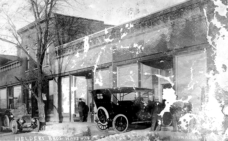
The stated route to downtown Champaign was indeed adopted and marked. After winding its way through Somer Township and west of Leverett, the trail entered Champaign on Market Street before making its way via Washington, Walnut, and Main, finally arriving at Neil Street.
In late August, the Courier reported that the trail from Ludlow north had been recently marked. “A man with a bucket of yellow paint, was here in a buggy and made yellow markings with the initials of the trail initials E. T. on the telegraph poles.” The notice also provides some specific details about the path of the trail through Ludlow and on to Paxton: “Coming from the south the trail traverses the Corbitt road, turns east at the L. N. Bear store, and runs one and one-half miles and then turns north straight into Paxton.”
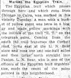
Bear, described as “one of the officers of the Egyptian trail organization,” is said to have “made the count of the poles painted in this neighborhood.” Other area section vice presidents, as reported in the Courier (June 18), included G. J. Johnson Paxton), J. A. Heinz (Pesotum), James Davidson (Arcola), and the aforementioned C. A. Kiler (Champaign) and C. E. Kelso (Thomasboro).
By the end of 1915 the complete path of the Egyptian Trail through Champaign County had been selected and marked. Since these early auto trails followed existing dirt roads worn down by horse and wagon traffic, they were in much need of improvement. That challenge would be tackled over the next few years, during which time two other issues would also emerge: the State of Illinois would finally respond calls from “good roads movement” advocates for government funding, and civic and business leaders in Urbana would revive efforts to get the highway routed through their city on the way to Rantoul. These developments will be the subject of Part Two: From Dirt Auto Trails to Paved State Highways.